
Chemin de Paris
View the L'Aigle / Domfront route on Google Map
View the Domfront / Le Mont road on Google Map
A little history
As the capital of the kingdom of France and the largest city in Europe in the Middle Ages, Paris was the destination of many pilgrims on their way to Mont-Saint-Michel. They generally took the same route from the Saint-Cloud bridge, sharing the route taken by pilgrims from Saint-Méen, in the diocese of Rennes, as far as Dreux.
Crossing the whole of Normandy, this mountain route, used throughout the Middle Ages and the modern era, has been accurately reconstructed thanks to various documents from the 15th and 16th centuries. After Dreux, it passed through Verneuil-sur-Avre, L'Aigle, Echauffour, Exmes, Argentan, Ecouché, Pain-d'Avaine (commune of Isigny-le-Buat) and Ducey. Once they reached the Bay of Mont à Bas-Courtils, there were only three more leagues along the shore to reach the sanctuary of the Archangel.
TODAY
The Paris to Mont Blanc route has been published in the GR® 22 Topoguide since 2012. The road to Mont-Saint-Michel, Paris-Alençon, Mont-Saint-Michel. The route from Paris to Verneuil-sur-Avre is that of the GR® 22 (pages 30 to 75). After Verneuil, the GR® 22 descends towards the Perche and no longer corresponds to the «Chemin du Mont» followed by the Miquelots for centuries, as it is simpler and, above all, shorter.
The «historic route» from Verneuil-sur-Avre is published in this guidebook as the ’Northern Option» and can be found on pages 148-189 for the stages from Verneuil to Domfront and on pages 119-127 for the Domfront/Mortain stage.
However, from Mortain, the GR® 22 climbs northwards to join the Chemin de Rouen at Saint-Michel-de-Montjoie, while the signposted Mont-Saint-Michel route, corresponding to the historic route, follows the voie verte via Isigny-le-Buat and Ducey (or Véloscénie)..
For more details on this guide, which is now only available from the Association, visit our Shop page
THE STAGES
From Paris to Verneuil-sur-Avre :![]() Paris / Chaville: follow the GR® 2
Paris / Chaville: follow the GR® 2
![]() Chaville / Petit-Jouy-les-Loges: take the GR® 22
Chaville / Petit-Jouy-les-Loges: take the GR® 22
![]() Les Loges-en-Josas / Villiers: take the GR® 11
Les Loges-en-Josas / Villiers: take the GR® 11
![]() Villiers / Saint-Léger-en-Yvelines: follow the GR® 1
Villiers / Saint-Léger-en-Yvelines: follow the GR® 1
![]() Saint-Léger-en-Yvelines / Verneuil-sur-Avre: take the GR® 22
Saint-Léger-en-Yvelines / Verneuil-sur-Avre: take the GR® 22
From Verneuil-sur-Avre to Mont :![]() Verneuil-sur-Avre / L'Aigle (30 km)
Verneuil-sur-Avre / L'Aigle (30 km)
![]() L'Aigle / Saint-Evroult-Notre-Dame-du-Bois (16.5 km)
L'Aigle / Saint-Evroult-Notre-Dame-du-Bois (16.5 km)
![]() Saint-Evroult-Notre-Dame-du-Bois / Gacé (24 km)
Saint-Evroult-Notre-Dame-du-Bois / Gacé (24 km)
![]() Gacé / Le Bourg-Saint-Léonard (22 km)
Gacé / Le Bourg-Saint-Léonard (22 km)
![]() Le Bourg-Saint-Léonard / Argentan (14.5 km)
Le Bourg-Saint-Léonard / Argentan (14.5 km)
![]() Argentan / Ecouché (20 km )
Argentan / Ecouché (20 km )
![]() Ecouché / Putanges-Pont-Ecrépin (16 km)
Ecouché / Putanges-Pont-Ecrépin (16 km)
![]() Putanges-Pont-Ecrépin / Briouze (21.3 km)
Putanges-Pont-Ecrépin / Briouze (21.3 km)
![]() Briouze / La Ferrière-aux-Etangs (18.8 km)
Briouze / La Ferrière-aux-Etangs (18.8 km)
![]() La Ferrière-aux-Etangs / Domfront (21.5 km)
La Ferrière-aux-Etangs / Domfront (21.5 km)
![]() Domfront / Lonlay-l'Abbaye (23 km)
Domfront / Lonlay-l'Abbaye (23 km)
![]() Lonlay-l'Abbaye / Mortain (28.5 km)
Lonlay-l'Abbaye / Mortain (28.5 km)
![]() Mortain / Isigny-le-Buat (23 km)
Mortain / Isigny-le-Buat (23 km)
![]() Isigny-le-Buat / Bas-Courtils (25 km)
Isigny-le-Buat / Bas-Courtils (25 km)
![]() Bas-Courtils / Mont-Saint-Michel (9 km)
Bas-Courtils / Mont-Saint-Michel (9 km)
From Paris to Le Mont, 22 stages and 522 km
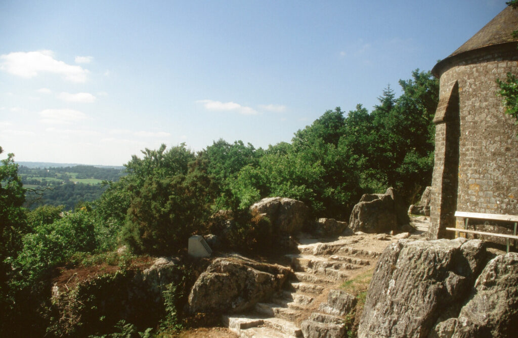 Mortain, View of the Mont from the chapel of Saint-Michel (Montjoie)
THE AREAS WE PASS THROUGH AND THEIR LANDSCAPES
After leaving Paris, the route crosses the Yvelines via the famous Rambouillet forest and bypasses Dreux to the north. It then leaves the Eure-et-Loir to pass through the Eure and into the Avre and Iton region as far as Verneuil. L'Aigle is its gateway to the Pays d'Ouche and the Orne, which it crosses from one side to the other, from the north, via the Perche and its many stud farms, the Argentan plain, the bocage and then the hilly Domfrontais countryside, before entering the Mortainais, from where, at last, the Mont can be seen...
- Verneuil-sur-Avre
NOT TO BE MISSED![]() Paris
Paris
![]() The forest of Rambouillet and its exceptional wildlife
The forest of Rambouillet and its exceptional wildlife
![]() Montfort-l'Amaury and its 16th-century monuments
Montfort-l'Amaury and its 16th-century monuments
![]() Anet and its Renaissance castle built for Diane de Poitiers
Anet and its Renaissance castle built for Diane de Poitiers
![]() Dreux (near the path)
Dreux (near the path)
![]() Nonancourtmedieval city
Nonancourtmedieval city
![]() Verneuil-sur-Avrecapital of the Avre and Iton region and former stronghold of the Hundred Years' War
Verneuil-sur-Avrecapital of the Avre and Iton region and former stronghold of the Hundred Years' War
![]() L'Aiglean ancient fortified town in the heart of the Pays d'Ouche, with its castle, churches and, in particular Saint-Martin)
L'Aiglean ancient fortified town in the heart of the Pays d'Ouche, with its castle, churches and, in particular Saint-Martin)
![]() Saint-Evroult-Notre-Dame-du-Bois and the ruins of its important abbey
Saint-Evroult-Notre-Dame-du-Bois and the ruins of its important abbey
![]() Gacé and its 15th-century castle
Gacé and its 15th-century castle
![]() Le Pin National Studthe "Versailles of the horse
Le Pin National Studthe "Versailles of the horse
![]() Exmesan ancient oppidum steeped in history that has survived the centuries
Exmesan ancient oppidum steeped in history that has survived the centuries
![]() Gouffern en Augethe 17th-century château at Bourg-Saint-Léonard and the abbey church at Silly
Gouffern en Augethe 17th-century château at Bourg-Saint-Léonard and the abbey church at Silly
![]() ArgentanA once fortified town and crossroads for the miquelots and jacquets.
ArgentanA once fortified town and crossroads for the miquelots and jacquets.
![]() Ecouché and its medieval village
Ecouché and its medieval village
![]() Ménil-Gondouin and its living, talking church
Ménil-Gondouin and its living, talking church
![]() Briouze and its Romanesque chapel of Saint-Gervais
Briouze and its Romanesque chapel of Saint-Gervais
![]() La Ferrière aux Etangs and its Saint-Michel rock
La Ferrière aux Etangs and its Saint-Michel rock
![]() Domfront, the medieval city where the ruins of the ramparts and castle are still visible
Domfront, the medieval city where the ruins of the ramparts and castle are still visible
![]() The abbey church in Lonlay-l'Abbaye
The abbey church in Lonlay-l'Abbaye
![]() Mortain, Saint-Michel chapel, l'Abbaye-Blanche, the collegiate church of Saint-Evroult and waterfalls
Mortain, Saint-Michel chapel, l'Abbaye-Blanche, the collegiate church of Saint-Evroult and waterfalls
![]() Naftel and its 15th-century polychrome cross in the church, with a pair of sculpted pilgrims
Naftel and its 15th-century polychrome cross in the church, with a pair of sculpted pilgrims
![]() Isigny-le-Buat and the Notre-Dame de Pain-d'Avaine chapel
Isigny-le-Buat and the Notre-Dame de Pain-d'Avaine chapel
![]() Duceywith its Renaissance château, ancient market town and old bridge over the Sélune.
Duceywith its Renaissance château, ancient market town and old bridge over the Sélune.
![]() Pontaubault and its historic bridge
Pontaubault and its historic bridge
THE DIFFICULTIES :![]() Many of the paths are very wet and others are rough, so climbing boots, a walking stick and good physical condition are essential!
Many of the paths are very wet and others are rough, so climbing boots, a walking stick and good physical condition are essential!![]() Accommodation capacity is very low in some parts of the Orne because of the forests or large rural areas through which it passes.
Accommodation capacity is very low in some parts of the Orne because of the forests or large rural areas through which it passes.![]() some stages are relatively long and need to be reorganised
some stages are relatively long and need to be reorganised![]() The start of the greenway from Mortain can seem monotonous
The start of the greenway from Mortain can seem monotonous
Special features
If you follow the green route, you can reach Mont-Saint-Michel either by crossing the Bay from Courtils or by taking the footbridge.
If you take the GR® 22 and then the Chemin du Mont-Saint-Michel from Rouen, you will cross the Bay from Genêts.
GPX FILES, STEP BY STEP, TO DOWNLOAD FOR GPS
These routes are given for guidance only and are not as accurate as the topographical texts accompanied by the 1:50,000 maps in the guide published by the Association.