
Chemin d'Orléans Chartres
The ORLEANS Way
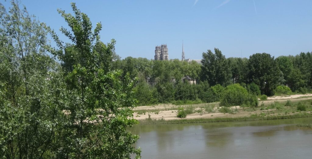
The route was defined and developed by the "Compostelle 28" and "Compostelle 45" associations, in cooperation with "Les Chemins du Mont-Saint-Michel". The route of this Grand Chemin from Orléans to Chartres follows the old Roman road between the two ancient cities.
It provides a link to Mont-Saint-Michel from the Loire Valley and beyond via Nevers, Lyon and Chambéry from Italy and France. Monte Gargano (Puglia), the primitive shrine of Saint Michael in the West and the model for Mount. Vézelay to Mont-Saint-Michel via Orléans and Chartres (for more information on this route, contact the Compostelle 45 associationAnother option is to follow the GR 654from Vézelay to La Charité-sur-Loire where the GR3 can be found, followed by the miquelots of Lyon to Orléans
Beyond Chartres, this itinerary follows the signposted route to the Mont via Thiron-Gardais, Nogent-le-Rotrou, Bellême, Alençon, Carrouges, Domfront, Mortain and Ducey. it is the Grand Chemin de Chartres (see below)
Its official presentation, scheduled for the spring, had to be postponed until the autumn because of the health crisis, but was finally held by videoconference at the end of 2020.
This new path is signposted towards the Mont with the Association's logo, and in the other direction, towards Monte Gargano.
NEW FOR SUMMER 2023
Publication of the "Grand Chemin de Chartres au Mont-Saint-Michel au départ d'Orléans" guidebook (23 stages, 449 km, 128-page heritage guide and 25 loose-leaf leaflets covering the 23 stages and a cycling option from Orléans to Chartres to join the Véloscénie.
Price €15 (plus postage)
For more details on this guide, see Guides
Steps
Orléans/Sougy (20.5 km)
Sougy/Orgères-en-Beauce (17 km)
Orgères-en-Beauce/Voves (13 km)
Voves/Morancez/Chartres (28.5 km)
A videoproduced by Compostelle 28, allows you to discover this two-thousand-year-old itinerary. which opened the door of the Mount to Italian pilgrims:
To consult the (provisional) list of accommodation on this route, go to accommodation
the step by step is available from Orléans to Chartres as a download
Step by step from Orléans to Chartres
GPX FILES, STEP BY STEP, TO DOWNLOAD FOR GPS
These routes are given for guidance only and are not as accurate as the topographical texts accompanied by the 1:50,000 maps in the guide published by the Association.
- The Chemin de CHARTRES
NEW FOR SUMMER 2023
Publication of the "Grand Chemin de Chartres au Mont-Saint-Michel au départ d'Orléans" guidebook (23 stages, 449 km, 128-page heritage guide and 25 loose-leaf leaflets covering the 23 stages and a cycling option from Orléans to Chartres to join the Véloscénie.
Price €15 (plus postage)
For more details on this guide, see the shop
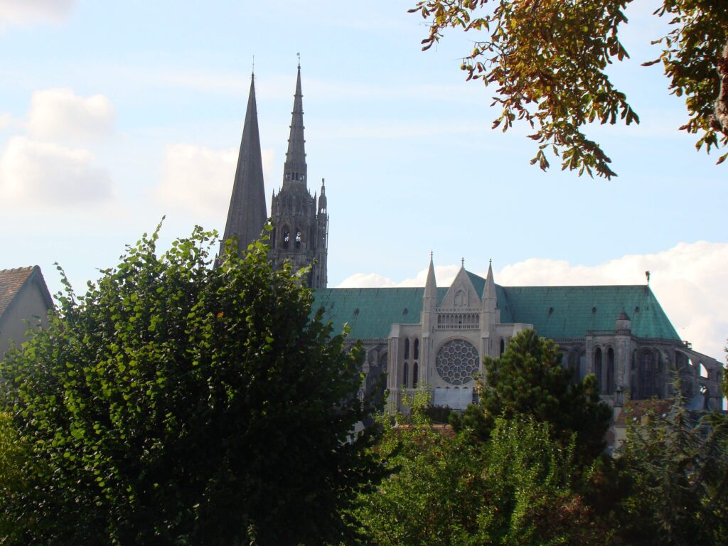
This route, which links two legendary sanctuaries of the medieval world and two masterpieces of medieval architecture listed as UNESCO World Heritage Sites, crosses the Beauce and Normandy regions following in the footsteps of the pilgrims of centuries gone by.
Chartres, a major Marian centre, attracted pilgrims who came to venerate a statue of the Virgin and Child and, above all, an insignificant relic known as the "Virgin's shirt". But the people of Chartres and the Beauce also venerated Saint Michael, and texts record pilgrimages to the Mount by people from all walks of life from the 11th to 17th centuries. After Nogent-le-Rotrou, capital of the Counts of Perche, they had to choose between Le Mans and Alençon.
The latter route, rehabilitated by the association as the Chemin du Mont-Saint Michel, follows the southern border of the Duchy of Normandy, marked by a series of fortresses held in the 11th-12th centuries by the powerful de Bellême family for the Duke of Normandy.
THE STAGES
Chartres / Fontenay-sur-Eure (17 km)
Fontenay-sur-Eure / Illiers-Combray (24.5 km)
Illiers-Combray / Thiron-Gardais (29.3 km) with the option of splitting the stage in two by stopping at Frazé (i.e. 19.8 km and 19.6 km for each of the two parts)
Thiron-Gardais / Nogent-le-Rotrou (20.4 km)
Nogent-le-Rotrou / Préaux-du-Perche (13 km)
Préaux-du-Perche / Bellême (20.7 km)
Bellême / La Perrière (13.7 km)
La Perrière / Neufchâtel-en-Saosnois (24 km)
Neufchâtel-en-Saosnois / Alençon (17.6 km)
Alençon / Livaie (21 km)
Livaie / Carrouges (16 km)
Carrouges / Bagnoles-de-l'Orne (29.7 km)
Bagnoles-de-l'Orne / Domfront (19.9 km)
Domfront / Lonlay-l'Abbaye (19 km)
Lonlay-l'Abbaye / Mortain (29.1 km)
Mortain / Isigny-le-Buat (23.5 km)
Isigny-le-Buat / Pontaubault (16 km)
Pontaubault / Mont-Saint-Michel (17.8 km)
Total Chartres / Le Mont: 370 km - 18 stages
The route from Chartres to Mont-Saint-Michel is published in the new guide to the "Grand Chemin de Chartres au Mont-Saint-Michel au départ d'Orléans" (23 stages, 449 km, 128-page heritage guide and 25 loose-leaf sheets corresponding to the 23 stages and a cycling alternative from Orléans to Chartres to join the Véloscénie).
Price €15 (plus postage)
For more details on this guide, see the shop
THE DIFFICULTIES :![]() Some stages take quite a long time
Some stages take quite a long time![]() Many of the paths can be wet and others rough, so climbing boots, a walking stick and good physical condition are essential!
Many of the paths can be wet and others rough, so climbing boots, a walking stick and good physical condition are essential!![]() Accommodation capacity is very low in some parts of the Orne because of the forests or large rural areas it crosses, but there is a fairly wide range of accommodation (bed and breakfasts, stopover gîtes, etc.) along the entire route.
Accommodation capacity is very low in some parts of the Orne because of the forests or large rural areas it crosses, but there is a fairly wide range of accommodation (bed and breakfasts, stopover gîtes, etc.) along the entire route.
THE AREAS WE PASS THROUGH AND THEIR LANDSCAPES
After crossing the cultivated plains of the Beauce region, which stretch as far as the eye can see, the route winds its way through the green hills of the Perche region to the great forest massifs of southern Orne (Bellême, Ecouves, Andaines, Perseigne), which it crosses from one side to the other via Alençon, Carrouges and Bagnoles-de-l'Orne. The route then crosses the Domfrontais hedged farmland, before entering the Mortainais region, where the Mont can finally be seen... Alternating between plains and hills, rural areas and forests, this picturesque, authentic and wild route will win you over.
NOT TO BE MISSED![]() Chartresits old quarters and its cathedral (UNESCO World Heritage site)
Chartresits old quarters and its cathedral (UNESCO World Heritage site)
![]() Illiers-Combraycity where the little Marcel Proust spent his holidays, and the church of Saint-Jacques
Illiers-Combraycity where the little Marcel Proust spent his holidays, and the church of Saint-Jacques
![]() The many charming churches of the Thironnais Perche region
The many charming churches of the Thironnais Perche region
![]() the medieval village of Frazé with its 15th-century castle and its Renaissance church
the medieval village of Frazé with its 15th-century castle and its Renaissance church
![]() The abbey from Thiron-Gardaishead of a monastic order, the Domaine de l'Abbaye and the Royal Collegenow open to visitors
The abbey from Thiron-Gardaishead of a monastic order, the Domaine de l'Abbaye and the Royal Collegenow open to visitors
![]() Nogent-le-Rotrouits castle belonging to the Counts of Perche, its ancient abbey and its churches
Nogent-le-Rotrouits castle belonging to the Counts of Perche, its ancient abbey and its churches
![]() The many manor houses in the Perche region, built in the aftermath of the Hundred Years' War
The many manor houses in the Perche region, built in the aftermath of the Hundred Years' War
![]() La PerrièreNotre-Dame church (12th century) and the bishop's residence
La PerrièreNotre-Dame church (12th century) and the bishop's residence
![]() The old strongholds on the defensive line of the Duchy of Normandy : Bellême and the gateway to its walled city (13th century); Alençonwith its castle and the churches of Notre-Dame and Saint-Léonard; Carrouges and its castle ; Domfront, the medieval citythe medieval city where the ruins of the ramparts and castle are still visible
The old strongholds on the defensive line of the Duchy of Normandy : Bellême and the gateway to its walled city (13th century); Alençonwith its castle and the churches of Notre-Dame and Saint-Léonard; Carrouges and its castle ; Domfront, the medieval citythe medieval city where the ruins of the ramparts and castle are still visible
![]() Bagnoles-de-l'Ornea charming spa nestling in a gorge of the river Vée
Bagnoles-de-l'Ornea charming spa nestling in a gorge of the river Vée
![]() The abbey church of Lonlay-l'Abbaye
The abbey church of Lonlay-l'Abbaye
![]() Mortain, Saint-Michel chapel, l'Abbaye-Blanche, the collegiate church of Saint-Evroult and waterfalls
Mortain, Saint-Michel chapel, l'Abbaye-Blanche, the collegiate church of Saint-Evroult and waterfalls
![]() Isigny-le-Buat and the Notre-Dame de Pain-d'Avaine chapel
Isigny-le-Buat and the Notre-Dame de Pain-d'Avaine chapel
![]() Duceywith its Renaissance château, ancient market town and old bridge over the Sélune.
Duceywith its Renaissance château, ancient market town and old bridge over the Sélune.
![]() Pontaubault and its historic bridge
Pontaubault and its historic bridge
GPX FILES, STEP BY STEP, TO DOWNLOAD FOR GPS
These routes are given for guidance only and are not as accurate as the topographical texts accompanied by the 1:50,000 maps in the guide published by the Association.
VARY THE PLEASURES!
Some areas of the Orne are not very suitable for equestrians and mountain bikers, and you may need to modify your itinerary slightly.
On the whole, however, this route can be used by bikes and horses, who will particularly enjoy crossing the great forests of the Orne or following the greenway between Domfront and Pontaubault. There is also a greenway between Condé-sur-Huisne and Alençon.
OPINION OF MIQUELOTS
"We're delighted with this beautiful route [from Alençon to Le Mont], most of which is through forests and undergrowth, which probably makes it even more enjoyable during the hot weather at the end of June. This Normandy bocage has often amazed and surprised us, it's so undulating, with unspoilt, ancient forests..." (Anne and Frédéric, July 2025).